
Kaaabbbbbbboooooooooommmm!
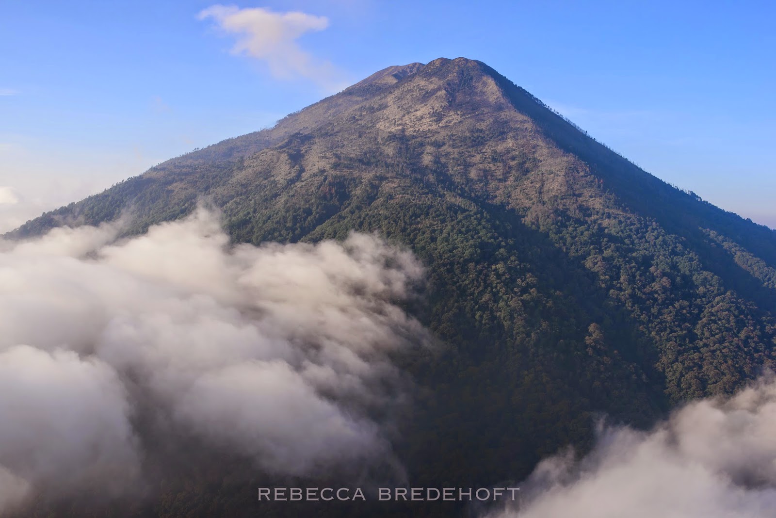
 There I was: at 13,045 feet above sea level, perched on a bed of course black sand. I was standing atop a massive conical mountaintop, surrounded by a sea of dreamy clouds. It was 6:14 AM. My four companions and I had ascended to the summit of Volcan Acatenango in the previous hours, climbing through the darkness and watching the sunrise wrapped in our paragliders to fend off the biting predawn cold. Mani, one of the Austrian Baba brothers, had been kiting his glider as the rising sun heated the ground and the first cycles of warm air drifted up the slope. He had balled his glider up and disappeared a few minutes prior down the hill below me, out of sight. I would later learn that he was enjoying a summit poop behind a large boulder. Cade, Jorge From da Island, and Mike (the other Baba brother) were a few hundred meters to the north, checking out the launch potential from the opposite edge of the crater.

.jpg)

But suddenly my peaceful moment was shattered by the loudest noise I have ever heard mother nature emit. I dropped the camera away from my eye and looked to the horizon, intuitively knowing the origin of the ground-shaking blast. A thick mushroom cloud of charcoal grey smoke was erupting from the narrow crater of Volcan de Fuego. My first thought: "What the Fuck." Mesmerized, I lifted my camera back to my eye and shot a quick burst of photos. As my thoughts caught up with me I wondered if I should run. I looked around. Jorge, Cade, and Mike were tiny stick figures on the horizon. Too far to yell. Should I run? My legs ached from the 5000 foot midnight climb. The smell of sulphur reached my nostrils. The noxious cloud was growing fast and drifting towards me. For a moment, just a moment, I wondered if I was about to die.


Now, I should explain. Had we done some research about these volcanoes, we would know that this eruption was relatively normal. Although Volcan de Fuego is an active volcano and has experienced life-threatening eruptions in the recent past (the last major one occurring in September of 2012), this little poof of ash and gas was fairly commonplace. We would later learn that the volcano was erupting many times per hour at the time of our adventure.
We had, in fact, done very little research about this mission at all. Twenty four hours prior we had received a message from our friend and local Guatemalan pilot Yankell Echeverria that predicted a favorable weather window for a flight from Acatenango's summit on the following day, the third of April. After a few tandem flights in Panajachel, we loaded up the van and headed towards Antigua. Jorge, Mike, and Mani were the only other motivated members of the team that were available on such short notice. We were a skeleton crew of our previous mission up Volcan Atitlan. The clouds were already towering as we drove out of Pana that afternoon. By the time we were pulling up to Yankell's house in Chimaltenango a few hours later, an electrical storm was raging. The lightning was periodically illuminating the dark sky, silhouetting the massive hulk of the volcano in the distance. We had pretty much given up on the idea of our hike and fly and had resigned ourselves to having a nice dinner in Antigua, getting a few rooms in a cheap hotel, and returning to Pana in the morning.
Yankell was much more confident about our chances. He said the weather would clear up for us and we'd have a nice light-wind window for flying in the morning. Our only concern would be a cloud layer below the summit. He showed us some beautiful photos from his tandem flight from Acatenango a few weeks prior, gave us a quick Google Earth tour of the area, and loaned Jorge a few essential items for the trek. He explained that we would start our hike in Soledad, a small town on the shoulder of the volcano, and that there was a futbol field surrounded by open fields there to land in. He gave us a radio that would transmit through a repeater and promised to be awake at 6 AM to consult with us about the weather. He explained that he preferred to hike the volcano at night to avoid the hot sun and told us the trail was well travelled and straightforward: the "Autopista" (freeway). He also gave us each a pair of disposable hand warmers and warned us that Acatenango was a "volcan frio" and sent us on our way. He had already arranged for us to meet with la familia Sis in Soledad that would have horses ready to help carry our gear to the summit. As we drove away, we wondered if Yankell had even walked outside to see the lightning show, but his optimism gave us enough hope to continue on towards our destination.
We found our way to Soledad in the dark, winding our way closer to the massive silhouette that was obscuring more and more of the horizon. There were a few raindrops on the windshield that we did our best to ignore, but the lightning was becoming less frequent. We arrived in the small town and found our way to the family's house. As we chatted with our Martin Sis and his family, the horses turned in to porters (there are horses, but they don't hike in the dark, they told us) and we agreed to start the hike at midnight, minimizing the time we'd have to wait for the sun to rise at the frigid summit. In the meantime, our hosts opened the kitchen for us to cozy up and stay warm for a few hours. We arranged our things, snacked, laughed, and got less than an hour of sleep before it was time to load up and start our way up the autopista with our five new friends and their two canine companions. Just before we left town, we asked about the futbol field. Yeah, over there, they pointed. No power lines. Flat. It's good. Okay.
As our eyes adjusted to the pitch black of the moonless night, we switched off our headlamps and fell in to a steady rhythm. We spread out along the autopista, whistling back and forth periodically to check in with each other. The trail was surprisingly good, and before long we could see town lights far into the distance in the valley below. The clouds started to break after a few hours, and the air grew much colder as we ascended into the sky. Although the darkness obscured much of our view, it allowed us to be in tune with many details of our surroundings and we marveled at the intoxicating smells of trailside flowers and silhouettes of gnarled trees above.
About three quarters of the way up the slope, Cade, Jorge and I caught up to the Babas. They had reached a severely cold layer of air and (being reminded of Yankell's 'volcan frio' warning) had stopped to wait for the porters, in the hopes of retrieving some extra layers from their glider bags. We waited, perched on the steep slope, shivering and rubbing our hands together, and whistled to the group of men that we had heard behind us only a few minutes before. We got no reply and, after twenty or thirty minutes, started to wonder if we were still on the right trail. We assumed they must have taken another route, but figured that as long as we were going up, we'd probably make it to the top. We distributed all the clothes we had with us and decided we should continue on to stay warm. We left the last vegetation behind and made our final push towards the bald summit. The air was noticeably harder to pull oxygen from up here and my head was aching.
As we reached the crest of the slope, we could see a few lights in front and below us and realized that we had gone astray somewhere. We were on top of the lower summit of Acatenango; the porters were in the saddle between us and the proper summit. As we reached them, they laughed and explained that we had missed a turn. They had (of course) taken the shorter route around the side to the saddle. They assured us it was only a few more minutes to the top and we pushed on through the dark together, dogs and all. As we crunched along on the coarse footing, we began to see palm-sized white circles amongst the volcanic rocks. I reached down and picked up an icy hockey puck. "Granizo," one of the porters explained. Hail. The whole summit was covered in it. I shook my head, thinking of the intensity of the storm here only a few hours before. He assured me we were almost there, "vamos, poco a poco."As we pushed on up the steep rocky terrain, my eyes started to burn. I could see something floating in the beams of the porters' headlamps. "Ceniza," my new friend said, as he saw me staring in awe. Ashes. Hmmm.

The porters did not stay long with us on the summit. We hugged and congratulated each other on a successful climb, and thanked them for the hard work of bringing our gliders to the top of the mountain. It is truly a gift to have the chance to fly from such a special place, and I am forever grateful to these guys for their help in making it happen. They bid us farewell and wished us a safe descent, asking when we might fly in the hopes of watching. As their figures grew smaller and disappeared into the darkness, the level of commitment once again sunk in. We were alone, high on top of the tallest point around with our paragliders, and although the wind was incredibly calm, there was likely a thick cloud layer below us. If we weren't able to fly, we would have a very long walk back down with our gear to Soledad.


The sunrise was stunning. As the light warmed our tired bodies and the clouds reflected some of the most perfect natural light I've ever seen onto our little encampment, we got our first view of the surroundings. Although there were spotty holes in the fluffy white sea below us, the clouds were developing quickly. We could not see any of our potential landing areas below. The tiny peak of Volcan de Agua, poking out of the the cloud layer across the valley, and Volcan de Fuego were our only landmarks.


 At six, we contacted Yankell on the radio. He was there, as promised. He told us that the layer was not as solid as it looked. He advised that we should wait for half an hour or more for the clouds to break up. We debated a little. Cade was ready to fly, and had in fact been walking around the summit with his harness on since the first inkling of morning appeared on the horizon. There was a hole to the north, in the vicinity of our potential landing area in Soledad, that appeared to be quickly closing. The rest of us were not ready to go. We hesitated. None of us had ever seen the futbol field that we were supposed to land in. For that matter, we had not even seen the town, or the fields, or the surrounding area in the daylight. What would we find below the clouds? Was the town in the clouds?


Then the volcano erupted. And the hesitation that we had felt only moments before suddenly melted away. We had some broken transmissions from Yankell, who was still encouraging us to wait, but we decided it was time to make a move. Mike, being the wily, intelligent, and well-prepared Austrian that he is, had set a waypoint in his compass at the familia Sis's house in Soledad before our ascent. Although we still weren't sure exactly where the futbol field was, we figured it had to be close-ish. After a few minutes of discussion, we decided that Mike would fly out over the clouds and mark the spot where the LZ should be, while the rest of us followed. We all agreed this was a good plan. The wind was blowing lightly up the south face of the crater, meaning we would be launching towards Volcan de Fuego. Our landing area was to the north, meaning we would need to launch, make a U-turn, traverse along the two summits of Acatenango, and find our landing area somewhere beneath the clouds.


 I was rapidly approaching the top of the cloud layer. There was one small hole in front of me and it was shrinking fast. Mani was high and further to the left with Mike. There was no following the GPS now. Cade made the executive decision and spiraled down into the hole in front of me. Jorge came from behind and followed him. As I reached the hole I looked down.... and saw nothing but cauliflower treetops. Fuck. I looked over my shoulder one last time at Acatenango, put my camera away, took a deep breath, and followed the boys. As I wingovered down through the white fluffiness, I saw nothing but fog and a carpet of trees. Fuck. Maybe this had been a bad idea.

And then I emerged below the layer. I was low to the ground. I quickly surveyed the landscape and realized there were fields in front of me. Safe landing areas. Whooo. I relaxed a little. It was foggy. I quickly picked out the shape of the dirt road we had driven in on the night before, and the curve of a ridgeline that my sleep-deprived brain remembered Yankell showing us on Google Earth. I followed the road with my eyes and found the houses of what must be Soledad in front of me. Jorge and Cade were ahead, pointed towards the small town. There was only one problem. There was a small rise between us and it, and we weren't going to clear it. We pointed that way anyways. I heard Jorge yell something to Cade. I picked out my landing areas, one after another, and somehow magically kept floating towards Soledad. I watched the boys clear the rise and glide towards the town, and still didn't believe I'd make it. And then I saw the rectangular dirt patch and the small metal goal posts of the futbol field. Were we going to make it?

I watched Jorge touch down in the middle of the field, and Cade right after him. I somehow cleared the rise, and pointed it for the futbol field. As I touched the ground, just over 12 minutes after I had left it 5000 feet above, I felt a huge smile take over my face. The Austrians weren't far behind, and we all hugged and jumped up and down, and recounted our individual experiences of the 12 minutes of beauty, uncertainty, and awe. As we packed up the gliders, the clouds broke and sunlight bathed the fields around us. We looked up, seeing the massive form of Acatenango emerge above us. Yankell was right. We should have waited 30 minutes.


We waved hello to all the curious residents as wandered through town, in search of the house where we had left the van seven hours before. A few asked if we were lost and where we were coming from. We found the van parked at a much more lively house, surrounded by horses, chickens, dogs, and la familia Sis. Mani and Mike chatted with a couple of Germans there that appeared to just be waking up. They looked sad. We loaded back up in the van, thanked our hosts, and pulled on to the dirt road. As we drove, Mike and Mani explained that the Germans had climbed the volcano the day before and had intended to camp on top. They had reached the saddle in the middle of the storm and had been forced to turn around because of the hail and lightning. We thanked the weather gods for blessing us with a perfect window, and marveled at our perfect timing, once again.

As we bumped down the dirt road, we all agreed it was time for a big breakfast. Sitting in a coffee shop in Antigua, surrounded by heaping plates of warm food and giant beverages, we laughed, smiled, and recounted the past 12 hours' adventure. As we've recounted the adventure to friends and each other again and again, one part keeps coming back, inspiring a newfound appreciation for mother nature's power in each one of us:
Kaaabbbbbbboooooooooommmm!


.jpg)


